The Czech Science Foundation has supported an international team led by Karel Nováček from the Department of History at the Palacký University Olomouc Faculty of Arts. Thanks to a subsidy of almost €360,000, the scientists were once again able to take off for Iraqi Kurdistan to study long-term development trends in the landscape, where they had discovered several prehistoric villages with fields. Their findings also aspire to help tackle the challenges facing our planet in the context of climate change.
Palacký University was recently awarded an exclusive five-year licence to explore an area located north of the city of Koya in Iraqi Kurdistan, approximately five hundred square kilometres in size. This prestigious licence was obtained mainly thanks to archaeologist Karel Nováček from the Department of History at the UP Faculty of Arts, who has been investigating the medieval urban network of northeastern Mesopotamia and has been working in Iraqi Kurdistan together with other experts since 2006.
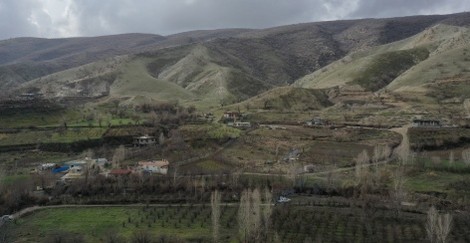
“In terms of archaeology, the Mesopotamian Plain has been documented fairly well, then especially southern Iraq, the cradle of city states and urban life. However, less conspicuous and visible but no less important processes were also taking place in the neighbouring mountains and mountain valleys. We already know that these areas were an important communications corridor, and our aim now is to formulate the hypothesis that the neighbouring mountains and mountain valleys were in some ways even more attractive than the Mesopotamian Plain. They had better ecological resilience,” said Nováček.

In describing the Mesopotamian basin, he emphasised its vulnerability to lack of rainfall.
“Although the given area is very fertile, it should be noted that it is located in a zone highly dependent on rainfall. And rainfall is unpredictable here. What can easily happen is that crops fail to germinate because winter rainfall is not sufficient. Although people have always tried to solve this problem with various irrigation systems, it is obviously much easier to grow crops in the mountain valleys, where water is abundant, temperatures do not reach extreme peaks during summers, and the ecosystem is more stable. We therefore believe that the solid core of ancient Mesopotamian civilisation, which was not manifested by power structures and large cities but by a robust agricultural system, can be found in these mountain valleys.”
Nováček and his team set out once again for a field survey of the four mountain valleys, which are separated by limestone peaks and are very rich in archaeological heritage, at the end of January.
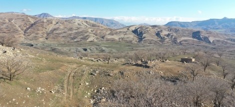
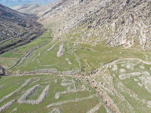
Last year he and his team carried out a baseline field survey in this area. In a small area of several villages, the team managed to find several dozen monuments dating back to the Stone Age, and on top of that one unique discovery. In an area of roughly forty hectares, traces of a vanished village with probable origins in the mid-fourth millennium BC were identified. Adjacent field systems might also have been discovered, which could contribute significantly to the understanding of the prehistoric agricultural landscape of the Fertile Crescent. Scientists will continue to investigate this area in future research using optically stimulated luminescence. This method involves extracting a sample of rock or soil that has remained untouched by sunlight since it was last handled by humans. The very fact that the rock has not been exposed to sunlight and has endured in the darkness until now allows them to date the moment of last exposure to light.
“The stones at the prehistoric field boundaries must have been carried to the spot and piled up by people. If we manage to extract a suitable sample, we should be able to date the moment when they established the field boundary,” added Nováček. He pointed out that the documentation from the baseline field survey is still being processed and evaluated.
“All aerial maps of the given area needed to be vectorised, i.e. redrawn in geographical information systems into the form of a field system layout. These have been currently completed. Now they need to be compared with older satellite images, mainly because of changes in the terrain.”
There are clearly more similar surface-visible sites in the area, and researchers will be able to explore them thanks to the support of the Czech Science Foundation.

“The main goal of the project, which is also of import to our Kurdish partners, is a detailed archaeological map of the area with all the sites we can identify, their dating, their extent in the landscape, and their expected significance. We will then address special issues, i.e. long-term development trends. In this sense, the most important thing for us is not whether the site is Palaeolithic, from a prehistoric agricultural period, or whether it is a village that was abandoned fifty years ago. All archaeological sites will be equally important to us,” explained Nováček on behalf of the team, which includes not only archaeologists who specialise in specific periods but also natural scientists. For example, botanists will study the development of the vegetation of the area over the last ten thousand years, at least. They will also be involved in ethnobotanical research, which includes guided interviews with witnesses about how farming used to be carried out, what machines and technologies were used, and what crops were grown.
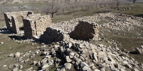
“In this sense, we’ve already collected a lot of data. It will be published in a forthcoming article about a village that disappeared during the Kurdish genocide in the 1980s. It was built at the end of the 19th century, in a rather distinctive manner. Due to the local wars in the 1970s and 1980s, it underwent several waves of destruction and rebuilding, and was abandoned during the last war. It is a model village to study what agricultural colonisation looked like in the 19th century and what changes the village underwent as a result of modernisation. Even though the agricultural land in Iraq has undergone dramatic changes in recent decades, no one has dealt with the subject in detail.”
According to Nováček, collaboration with specialists in geoarchaeology will also be essential.
“The local landscape looked rather different ten thousand years ago. Its relief has been marked by human activity, while other changes have occurred due to erosion and accumulation. Specialists could help us identify those changes. There are promising prospects of cooperation with the geoarchaeological team of the University of Milan, which runs their own research projects in Kurdistan in areas similar to ours,” said the Palacký University archaeologist, a few weeks before the first of five planned field surveys began.

This year, the team plans to undertake at least two trips. The months of January and February are particularly suitable for their purposes, because the landscape is extremely legible at this time. There is no grass, so the experts can collect surface artefacts, and all the significant colour differences, for example in the topsoil, are visible. Although the weather there is unpredictable during these months, it offers excellent visibility. In the autumn, UP scientists will take off for a second time. However, it is possible that in the spring when the land is covered with vegetation, another trip will be made, for the sake of the botanists in particular. Next year, two more trips are planned, and in the third and final year of the project, the last one will be made. All in all, they will spend at least five working months in the region.
“Our project is exploratory, non-destructive, and dedicated mainly to mapping and collecting surface-visible archaeological finds. We anticipate finding a variety of sites. We are aware of fortress systems, there is a roughly 80-hectare vanished town in the territory. We haven’t yet paid any attention to the local caves, and there are many of them there. Having said that, we will first focus on a locality that will soon disappear underwater. Because of the desperate lack of water in Kurdistan, a second dam is being built in the region,” said Nováček.
Together with his team of experts, he investigates the archaeology of a vulnerable landscape that had been of considerable importance in the history of northern Iraq. The issues studied have obvious overlap with the present. The Middle East and northern Iraq, as well as the entire planet, are undergoing climate change, which is manifesting itself in very intense and rapid desiccation and water scarcity.
“If we can uncover the mechanisms that allowed mountain areas in the past to remain in a stable condition and dynamic equilibrium, we might even propose some ways to revive these mechanisms.”
The three-year project, entitled “A tale of four valleys in mountainous Kurdistan: Past landscape strategies, resilience, and sustainability in a long-term perspective”, could not have happened without the collaboration of the Directorate General of Antiquities and Heritage of Kurdistan, the Cultural Heritage Inspectorate in Koya, and the University of Koya, on whose campus the international team supported by the Czech Science Foundation is based during the surveys. Two PhD students from this university are studying at Palacký University in the summer semester, within the framework of the Erasmus+ programme.
